Questions from the Field ..."I recently moved and I would like to reset the declination on my trusty old compass. The problem is that I have lost the manual that came with it. How can I find the declination for my new location?"Unless your compass is quite new (less than 5 years old), the manual would not be of
much help anyway. Let us explain. As we all learned in basic surveying or geography, the
earth acts like a giant magnet which as two poles - one pointing north and one pointing
south. Since a compass needle is magnetized, its direction is controlled by the magnetic
forces at the earth's surface and will seek the magnetic north pole. However, the axis of
the earth's magnetic field does not coincide exactly with the axis of the earth's rotation
about the north and south poles (the north magnetic pole lies in the Arctic islands of
Canada). Maps and directions are usually based on this true north rather than magnetic
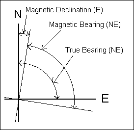
north. Magnetic declination is the angular difference between the true north (true
meridian) and magnetic north (magnetic meridian). This difference, or declination, can be
manually added (if declination is westerly) or subtracted (if declination is easterly) to
a compass reading to get the direction from true north. Fortunately most compasses come
with an offset mechanism that will "automatically" make this adjustment. It is
not really "automatic" because you'll need to change settings if you change to
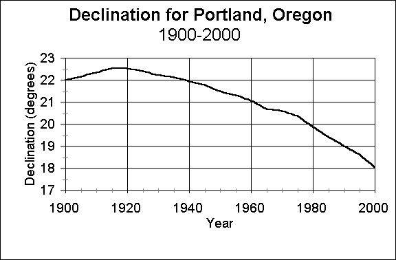
areas of different declination (that's how we got here). Compass manuals usually come with a figure that shows lines of equal declination (usually 2 or 5 degrees) over a map. This is called an isogonic chart. For an example, see Figure 3-3 (page 38) in the fourth edition (1994) or Figure 2-3 (page 14) third edition (1983) of Forest Measurements by Avery and Burkhart. In the U.S., these charts are published by the Geological Survey about every five years. Most people know about this. What people often forget is that declination is constantly changing (your compass manual probably says this). This change is gradual and is called secular variation and seems to be cyclic in nature. In the U.S. and Canada, declination may swing for several degrees east or west over many years before it swings back like a pendulum in the other direction. Some isogonic charts will also show the annual change in declination, which can be several minutes. But to make things more complicated, this secular variation is not constant, making declination maps only good for a few years. This is why your old compass manual may not be of much help if it is very old. One interesting line on an isogonic chart is the agonic line. This is the line of zero
declination and is where a magnetic needle points to true north. If you were to look at a
1970 isogonic map of the U.S., this line would go through the Lakes Superior and Michigan
and down through Indiana, Kentucky, North Carolina, Georgia and down the center of
Florida. In 1995 this line was on the western edge of Lake Superior and goes down through
Wisconsin, Illinois, western Tennessee and between Mississippi and Alabama. To show the
historical change in declination, below is a graph of the declination in Portland, Oregon
from 1900 to 2000. There is a magnetic observatory system begun in the 1830's to record the earth's magnetic field. Currently the U.S. Geological Survey (USGS) has 13 magnetic observatories that report near-real time data by satellite. This data is used to develop isogonic charts and more recently, models. So how can you get an updated isogonic chart? If you are in the US you can go to the USGS web site at http://geomag.usgs.gov. This site has a lot of interesting information in addition to the latest isogonic maps of the U.S., which can be printed or purchased for a small fee. If you want to know the declination values more precisely, or for years past, you can go to National Geophysical Data Center (NOAA) site at http://www.ngdc.noaa.gov/seg/potfld/geomag.shtml and select "Geomag Declination online". Here you can put in your location (as latitude and longitude or zip code) and a date and get the declination. If you are in Canada you can do the same thing using the Canadian Geomagnetic Reference Field at http://www.geolab.nrcan.gc.ca/geomag/e_cgrf.html. So how big of a deal is it to know the correct declination? If you are using your compass just for field bearing, then declination can be ignored. But if you are using maps or map bearings, allowance for declination should be made. How close do you need to know declination? You'll have to decide, depending on what you are doing. For example, if you measure out one mile and your angle is off by 1 degree, you will be off by about 92 feet (5280*SIN(1o) = 92.15). The current difference in declination between Portland, OR and Olympia, WA (114 miles up Interstate 5) is 37.1 minutes. One other application where declination can be important is in following historic maps or bearings based on magnetic declination. In this case, both the current and past (when the map was made) declination are needed. Convert the old magnetic bearing to its true bearing using the old declination. Then update the old true bearing to a current magnetic bearing by applying the current declination. One other interesting observation about compasses is that is called compass dip. We are all aware of the horizontal aspect of the earth's magnetic attraction we call declination. Because the attraction is towards the magnetic poles, it is only truly horizontal halfway between the poles. The vertical component becomes stronger towards the poles and attraction become vertical at the poles. Compasses are generally built to compensate for this dip so you don't have to worry about it unless your work ranges very widely in a North-South direction. |