Questions from the field...
Couldn't You Just Move the Edge Outward?
This question came up at a short course when we were discussing how to correct for plots falling near stand edges. It is an ingenious question (as questions from practical people often are). As a matter of fact, you can. Two methods already do this.
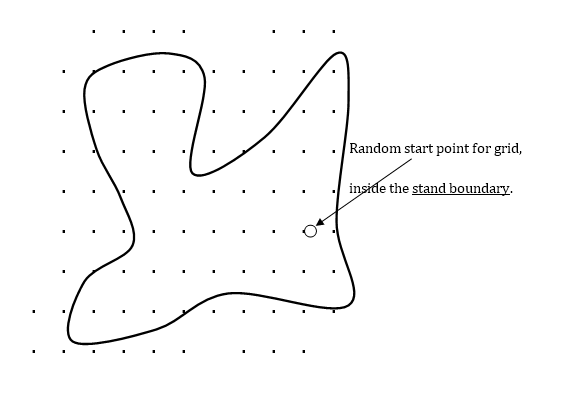
The first method is the “Toss-back” method, introduced in 2001. Those of you with a Sampler book can look on page 641 for a recent description. In this system, you put plots out as far as you need to (far enough that you will no longer see a tree in the stand from those outer plots), and only count trees inside the stand when they fall onto a plot on any sample plots. You do not need to do “edge corrections”, since the outer plots are doing that for you. All these plot locations are laid out on a grid starting from a random point inside the stand. When you see a tree “in” from the plot, just add it to one of the plots already inside the stand -- as if it was found there. You do the statistics just like you normally do, using only plots inside the stand, with some of the plots in the stand having these “extra” trees. This is an unbiased estimate of the volume/acre for the stand. To get the total volume, you would multiply by the acres of the stand as you do with standard fixed or variable plot sampling.
Figure 1: The "Toss Back" Method
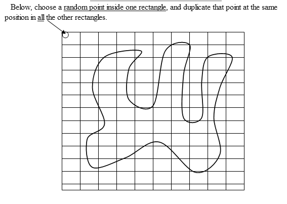
The second method, the “Area-Independent” method, is a variation of this technique. With this method, you first put a grid of squares or rectangles over the area. Put in rectangles far enough away that you will never see a tree from a rectangle further away. Next, you pick a random point in one of the rectangles, and put in plots at the same relative location in all the other rectangles (giving a systematic sample). This issue of how you place the starting point of the grid is a critical distinction between the systems.
Again, count only trees that are inside the stand, no matter where the plot location falls. Some of your sample plots will have zero trees. This is not a problem. Get the average data for all the plots, and multiply that average by the area implied by the rectangles (not the stand area). You now have the total volume of the smaller stand covered by these rectangles (but not the volume/acre in the stand). To get the volume per acre in that stand, you need to have the stand area, but perhaps you do not need that.
Figure 2: The Area-Independent Method
The ideas are very similar in these two methods. Both are unbiased and useful. Those who have difficult problems with riparian zones, or very tricky borders, may find these methods of use. They do not rely on knowing the exact boundary of the stand – you just need to know if the trees (and perhaps the plot location) are inside that stand boundary.
Imagine a situation where you have a strange and possibly unidentified ecological border around trees near a stream. You can tell if the trees are in the ecological area (perhaps by species), but the actual edge can only be determined by a specialist, and they cannot be bothered.
1) The Area-Independent method can handle that, and gives you a total for the trees.
2) If you can tell whether you are in that ecological area, the Toss-back method will solve the problem and tell you the volume/acre.
These methods work with fixed or variable plots, and of course with other items than trees, which is just an example here. Not having to specify the exact boundary location or do edge corrections might be a considerable practical advantage. It makes no difference whether the boundary loops around in complicated ways or is a simple fence line.
The calculation of statistics with the “Toss-back” are already OK (as far as any statistics are OK when you use a systematic sample). With the Area-Independent method, you might use the same approach as the Toss-back and do the statistics after adding any outside trees to plots within the stand. This would be a reasonable approximation, in my opinion. Some regulations or decisions are based on a per/acre basis, and some on an overall total. If you want to avoid surveying the stand boundary, that will decide the method for you to choose. If you have stand area, either can be used.
References:
Iles, 2003, “The Toss-back method”, A Sampler of Inventory Topics, chapter 14.
Flewelling and Iles, 2004, “Area-Independent Sampling for Total Basal Area”. Forest Science, Volume 50, Number 4, pp. 512-517(6)